Last active
February 12, 2021 11:19
-
-
Save OlegJakushkin/506277ed98dd6a7a79c9082a4a158ecd to your computer and use it in GitHub Desktop.
olejak/gis
This file contains hidden or bidirectional Unicode text that may be interpreted or compiled differently than what appears below. To review, open the file in an editor that reveals hidden Unicode characters.
Learn more about bidirectional Unicode characters
| #!/bin/bash | |
| # | |
| # Requires: | |
| # - gdal_sieve.py | |
| # - ogr2ogr (GDAL) | |
| # - topojson (node.js) | |
| # Grab the relative directory for source file. | |
| SRC_DIR=`dirname $0` | |
| # Which raster to compress. | |
| ORG_FILE="$SRC_DIR/Rome-DEM.tif" | |
| # Final output file. | |
| OUTPUT_FILE="$SRC_DIR/Rome.json" | |
| echo "Processing $ORG_FILE." | |
| # Where to output the new file. | |
| TMP_DIR=./tmp | |
| # The amount of times the file should be passed over. | |
| ITERATIONS=3 | |
| # Threshold for each iteration. | |
| THRESHOLD=40 | |
| # TopoJSON area threshold for simplification. | |
| TOPO_COMPRESSION=0.005 | |
| # Setup internal vars. | |
| _CUR=$THRESHOLD | |
| _COMPRESSION=$(($ITERATIONS * $THRESHOLD)) | |
| rm -rf $TMP_DIR | |
| mkdir -p $TMP_DIR | |
| # Start sieve passes. | |
| gdal_sieve.py -st $THRESHOLD -4 $ORG_FILE $TMP_DIR/output-"$THRESHOLD".tiff | |
| while [ $_CUR -le $_COMPRESSION ]; do | |
| let _PREV=$_CUR | |
| let _CUR=$_CUR+$THRESHOLD | |
| echo "Compressing output-$_PREV.tiff into $_CUR.tiff" | |
| gdal_sieve.py -st $THRESHOLD -4 "$TMP_DIR/output-$_PREV.tiff" \ | |
| "$TMP_DIR/output-$_CUR.tiff" | |
| rm "$TMP_DIR/output-$_PREV.tiff" | |
| done | |
| # Raster to vector. | |
| gdal_polygonize.py $TMP_DIR/output-"$_CUR".tiff \ | |
| -f "ESRI Shapefile" $TMP_DIR vector n | |
| # Change shapefile to geojson without the 0 layer, which is water. | |
| ogr2ogr -f "GeoJSON" -where "n != 0" "$TMP_DIR/geojson.json" $TMP_DIR/vector.shp | |
| # Convert to compressed TopoJSON. | |
| geo2topo -o $OUTPUT_FILE \ | |
| --no-stitch-poles \ | |
| -s $TOPO_COMPRESSION \ | |
| -p -- "$TMP_DIR/geojson.json" | |
| # Clean up. | |
| rm -rf $TMP_DIR |
This file contains hidden or bidirectional Unicode text that may be interpreted or compiled differently than what appears below. To review, open the file in an editor that reveals hidden Unicode characters.
Learn more about bidirectional Unicode characters
| { | |
| "cells": [ | |
| { | |
| "cell_type": "code", | |
| "execution_count": null, | |
| "id": "current-cannon", | |
| "metadata": {}, | |
| "outputs": [], | |
| "source": [ | |
| "# docker run --rm -p 10000:8888 -e JUPYTER_ENABLE_LAB=yes --user root -e NB_GID=100 -e GEN_CERT=yes -e GRANT_SUDO=yes -v C:\\TestDir:/home/jovyan/work --name ojgis2 jupyter/datascience-notebook:lab-2.2.9\n", | |
| "from jupyter/datascience-notebook:lab-2.2.9\n", | |
| "USER 0\n", | |
| "ARG MapboxAccessTokenJupyter=pk.eyJ1Ijoic3VwZXJpb3IwIiwiYSI6ImNrbDF3NThvaTAyZGgyb3J3OGpiaGx0Y3IifQ.5_I3PuByqUc-PkDBMuSzUQ\n", | |
| "\n", | |
| "RUN apt-get update && \\\n", | |
| " apt-get install -y software-properties-common python-numpy htop mc gdal-bin libgdal-dev && \\\n", | |
| " pip install keplergl elevation rasterio topojson && \\\n", | |
| " pip uninstall -y keplergl\n", | |
| "\n", | |
| "RUN npm install -g --force yarn topojson-server topojson && \\\n", | |
| " pip install GDAL==3.0.4 && \\\n", | |
| " pip install raster2xyz\n", | |
| "\n", | |
| "RUN echo \"fs.inotify.max_user_watches=524288\" >> /etc/sysctl.conf\n", | |
| "\n", | |
| "RUN git clone --recursive https://github.com/keplergl/kepler.gl && \\\n", | |
| " cd ./kepler.gl/bindings/kepler.gl-jupyter && cd js && yarn && npm run build && \\\n", | |
| " cd ../ && pip install -e .\n", | |
| "\n", | |
| "RUN cd ./kepler.gl/bindings/kepler.gl-jupyter \\\n", | |
| " && jupyter nbextension install --py --symlink --sys-prefix keplergl \\\n", | |
| " && jupyter nbextension enable --py --sys-prefix keplergl\n", | |
| "\n", | |
| "RUN cd ./kepler.gl/bindings/kepler.gl-jupyter \\\n", | |
| " && jupyter labextension install @jupyter-widgets/jupyterlab-manager \\\n", | |
| " && jupyter labextension install js" | |
| ] | |
| }, | |
| { | |
| "cell_type": "code", | |
| "execution_count": null, | |
| "id": "solved-scoop", | |
| "metadata": {}, | |
| "outputs": [], | |
| "source": [] | |
| }, | |
| { | |
| "cell_type": "code", | |
| "execution_count": null, | |
| "id": "thermal-hanging", | |
| "metadata": {}, | |
| "outputs": [], | |
| "source": [ | |
| "\n" | |
| ] | |
| }, | |
| { | |
| "cell_type": "code", | |
| "execution_count": null, | |
| "id": "sexual-birth", | |
| "metadata": {}, | |
| "outputs": [], | |
| "source": [ | |
| "import os\n", | |
| "'GDAL_DATA' in os.environ\n", | |
| "!fio env --gdal-data\n", | |
| "!export GDAL_DATA=/opt/conda/lib/python3.8/site-packages/fiona/gdal_data\n", | |
| "os.environ['GDAL_DATA'] = '/opt/conda/lib/python3.8/site-packages/fiona/gdal_data'\n", | |
| "os.environ['MapboxAccessTokenJupyter'] = 'pk.eyJ1Ijoic3VwZXJpb3IwIiwiYSI6ImNrbDF3NThvaTAyZGgyb3J3OGpiaGx0Y3IifQ.5_I3PuByqUc-PkDBMuSzUQ'" | |
| ] | |
| }, | |
| { | |
| "cell_type": "code", | |
| "execution_count": null, | |
| "id": "czech-relevance", | |
| "metadata": {}, | |
| "outputs": [], | |
| "source": [ | |
| "!eio selfcheck\n", | |
| "!eio clip -o Rome-DEM.tif --bounds 12.35 41.8 12.65 42" | |
| ] | |
| }, | |
| { | |
| "cell_type": "code", | |
| "execution_count": null, | |
| "id": "falling-graham", | |
| "metadata": {}, | |
| "outputs": [], | |
| "source": [] | |
| }, | |
| { | |
| "cell_type": "code", | |
| "execution_count": null, | |
| "id": "coordinate-moment", | |
| "metadata": {}, | |
| "outputs": [], | |
| "source": [ | |
| "import rasterio\n", | |
| "import rasterio.features\n", | |
| "import rasterio.warp\n", | |
| "from rasterio.plot import show\n", | |
| "from matplotlib import pyplot\n", | |
| "with rasterio.open('Rome-DEM.tif') as dataset:\n", | |
| "\n", | |
| " # Read the dataset's valid data mask as a ndarray.\n", | |
| " mask = dataset.dataset_mask()\n", | |
| "\n", | |
| " # Extract feature shapes and values from the array.\n", | |
| " for geom, val in rasterio.features.shapes(\n", | |
| " mask, transform=dataset.transform):\n", | |
| "\n", | |
| " # Transform shapes from the dataset's own coordinate\n", | |
| " # reference system to CRS84 (EPSG:4326).\n", | |
| " geom = rasterio.warp.transform_geom(\n", | |
| " dataset.crs, 'EPSG:4326', geom, precision=6)\n", | |
| " \n", | |
| " fig, ax = pyplot.subplots(1, figsize=(12, 12))\n", | |
| " #show(dataset.read(), transform=dataset.transform)\n", | |
| " show((dataset, 1), cmap='Greys_r', interpolation='none', ax=ax)\n", | |
| " show((dataset, 1), contour=True, ax=ax)\n", | |
| " pyplot.show()\n", | |
| "!rio shapes 'Rome-DEM.tif' --bidx 1 --precision 6 > shade.geojson" | |
| ] | |
| }, | |
| { | |
| "cell_type": "code", | |
| "execution_count": null, | |
| "id": "helpful-incident", | |
| "metadata": {}, | |
| "outputs": [], | |
| "source": [] | |
| }, | |
| { | |
| "cell_type": "code", | |
| "execution_count": null, | |
| "id": "coordinate-marketplace", | |
| "metadata": {}, | |
| "outputs": [], | |
| "source": [] | |
| }, | |
| { | |
| "cell_type": "code", | |
| "execution_count": null, | |
| "id": "twelve-despite", | |
| "metadata": {}, | |
| "outputs": [], | |
| "source": [ | |
| "!./geotiff-to-geojson.sh" | |
| ] | |
| }, | |
| { | |
| "cell_type": "code", | |
| "execution_count": null, | |
| "id": "mysterious-feedback", | |
| "metadata": {}, | |
| "outputs": [], | |
| "source": [ | |
| "from raster2xyz.raster2xyz import Raster2xyz\n", | |
| "\n", | |
| "input_raster = \"Rome-DEM.tif\"\n", | |
| "out_csv = \"Rome.csv\"\n", | |
| "\n", | |
| "rtxyz = Raster2xyz()\n", | |
| "rtxyz.translate(input_raster, out_csv)" | |
| ] | |
| }, | |
| { | |
| "cell_type": "code", | |
| "execution_count": 2, | |
| "id": "concrete-fancy", | |
| "metadata": {}, | |
| "outputs": [ | |
| { | |
| "name": "stdout", | |
| "output_type": "stream", | |
| "text": [ | |
| "User Guide: https://docs.kepler.gl/docs/keplergl-jupyter\n" | |
| ] | |
| }, | |
| { | |
| "data": { | |
| "application/vnd.jupyter.widget-view+json": { | |
| "model_id": "761cd593fd674ea5a643867222004055", | |
| "version_major": 2, | |
| "version_minor": 0 | |
| }, | |
| "text/plain": [ | |
| "KeplerGl(config={'version': 'v1', 'config': {'visState': {'filters': [], 'layers': [{'id': 'xxu0rsf', 'type': …" | |
| ] | |
| }, | |
| "metadata": {}, | |
| "output_type": "display_data" | |
| } | |
| ], | |
| "source": [ | |
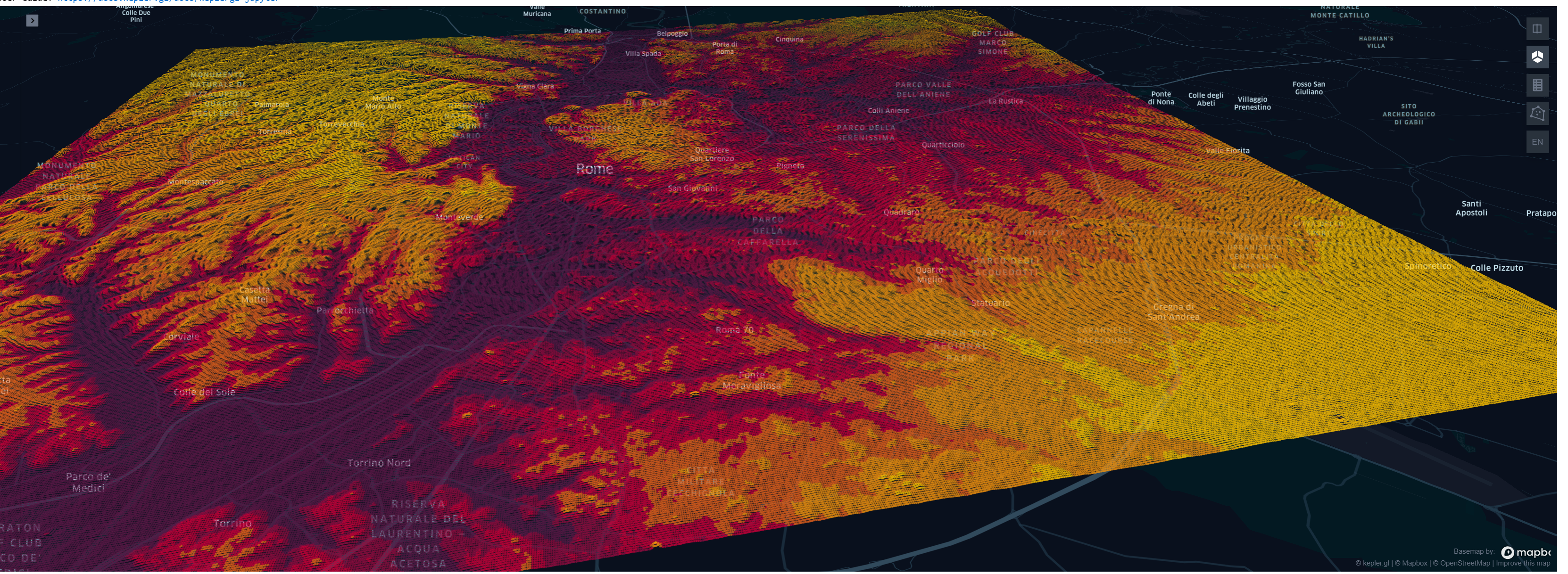
| "from keplergl import KeplerGl\n", | |
| "import pandas as pd\n", | |
| "from geopandas import GeoDataFrame\n", | |
| "from shapely.geometry import Point\n", | |
| "import fiona\n", | |
| "\n", | |
| "\n", | |
| "df = pd.read_csv('Rome.csv')\n", | |
| "\n", | |
| "geometry = [Point(xy) for xy in zip(df.x, df.y)]\n", | |
| "crs = {'init': 'epsg:2263'} #http://www.spatialreference.org/ref/epsg/2263/\n", | |
| "geo_df = GeoDataFrame(df, crs=crs, geometry=geometry)\n", | |
| "config = {\n", | |
| " \"version\": \"v1\",\n", | |
| " \"config\": {\n", | |
| " \"visState\": {\n", | |
| " \"filters\": [],\n", | |
| " \"layers\": [\n", | |
| " {\n", | |
| " \"id\": \"xxu0rsf\",\n", | |
| " \"type\": \"point\",\n", | |
| " \"config\": {\n", | |
| " \"dataId\": \"depth\",\n", | |
| " \"label\": \"depth\",\n", | |
| " \"color\": [\n", | |
| " 18,\n", | |
| " 147,\n", | |
| " 154\n", | |
| " ],\n", | |
| " \"columns\": {\n", | |
| " \"lat\": \"y\",\n", | |
| " \"lng\": \"x\",\n", | |
| " \"altitude\": \"z\"\n", | |
| " },\n", | |
| " \"isVisible\": True,\n", | |
| " \"visConfig\": {\n", | |
| " \"radius\": 5.2,\n", | |
| " \"fixedRadius\": False,\n", | |
| " \"opacity\": 0.59,\n", | |
| " \"outline\": False,\n", | |
| " \"thickness\": 0.5,\n", | |
| " \"strokeColor\": None,\n", | |
| " \"colorRange\": {\n", | |
| " \"name\": \"Global Warming\",\n", | |
| " \"type\": \"sequential\",\n", | |
| " \"category\": \"Uber\",\n", | |
| " \"colors\": [\n", | |
| " \"#5A1846\",\n", | |
| " \"#900C3F\",\n", | |
| " \"#C70039\",\n", | |
| " \"#E3611C\",\n", | |
| " \"#F1920E\",\n", | |
| " \"#FFC300\"\n", | |
| " ]\n", | |
| " },\n", | |
| " \"strokeColorRange\": {\n", | |
| " \"name\": \"Global Warming\",\n", | |
| " \"type\": \"sequential\",\n", | |
| " \"category\": \"Uber\",\n", | |
| " \"colors\": [\n", | |
| " \"#5A1846\",\n", | |
| " \"#900C3F\",\n", | |
| " \"#C70039\",\n", | |
| " \"#E3611C\",\n", | |
| " \"#F1920E\",\n", | |
| " \"#FFC300\"\n", | |
| " ]\n", | |
| " },\n", | |
| " \"radiusRange\": [\n", | |
| " 0,\n", | |
| " 50\n", | |
| " ],\n", | |
| " \"filled\": True\n", | |
| " },\n", | |
| " \"hidden\": False,\n", | |
| " \"textLabel\": [\n", | |
| " {\n", | |
| " \"field\": None,\n", | |
| " \"color\": [\n", | |
| " 255,\n", | |
| " 255,\n", | |
| " 255\n", | |
| " ],\n", | |
| " \"size\": 18,\n", | |
| " \"offset\": [\n", | |
| " 0,\n", | |
| " 0\n", | |
| " ],\n", | |
| " \"anchor\": \"start\",\n", | |
| " \"alignment\": \"center\"\n", | |
| " }\n", | |
| " ]\n", | |
| " },\n", | |
| " \"visualChannels\": {\n", | |
| " \"colorField\": {\n", | |
| " \"name\": \"z\",\n", | |
| " \"type\": \"integer\"\n", | |
| " },\n", | |
| " \"colorScale\": \"quantile\",\n", | |
| " \"strokeColorField\": None,\n", | |
| " \"strokeColorScale\": \"quantile\",\n", | |
| " \"sizeField\": None,\n", | |
| " \"sizeScale\": \"linear\"\n", | |
| " }\n", | |
| " }\n", | |
| " ],\n", | |
| " \"interactionConfig\": {\n", | |
| " \"tooltip\": {\n", | |
| " \"fieldsToShow\": {\n", | |
| " \"depth\": [\n", | |
| " {\n", | |
| " \"name\": \"x\",\n", | |
| " \"format\": None\n", | |
| " },\n", | |
| " {\n", | |
| " \"name\": \"y\",\n", | |
| " \"format\": None\n", | |
| " },\n", | |
| " {\n", | |
| " \"name\": \"z\",\n", | |
| " \"format\": None\n", | |
| " }\n", | |
| " ]\n", | |
| " },\n", | |
| " \"compareMode\": False,\n", | |
| " \"compareType\": \"absolute\",\n", | |
| " \"enabled\": True\n", | |
| " },\n", | |
| " \"brush\": {\n", | |
| " \"size\": 0.5,\n", | |
| " \"enabled\": False\n", | |
| " },\n", | |
| " \"geocoder\": {\n", | |
| " \"enabled\": False\n", | |
| " },\n", | |
| " \"coordinate\": {\n", | |
| " \"enabled\": False\n", | |
| " }\n", | |
| " },\n", | |
| " \"layerBlending\": \"normal\",\n", | |
| " \"splitMaps\": [],\n", | |
| " \"animationConfig\": {\n", | |
| " \"currentTime\": None,\n", | |
| " \"speed\": 1\n", | |
| " }\n", | |
| " },\n", | |
| " \"mapState\": {\n", | |
| " \"bearing\": 12.5817852288174,\n", | |
| " \"dragRotate\": True,\n", | |
| " \"latitude\": 41.89028347702737,\n", | |
| " \"longitude\": 12.462709954174432,\n", | |
| " \"pitch\": 59.50249662967758,\n", | |
| " \"zoom\": 13.769164917078767,\n", | |
| " \"isSplit\": False\n", | |
| " },\n", | |
| " \"mapStyle\": {\n", | |
| " \"styleType\": \"dark\",\n", | |
| " \"topLayerGroups\": {},\n", | |
| " \"visibleLayerGroups\": {\n", | |
| " \"label\": True,\n", | |
| " \"road\": True,\n", | |
| " \"border\": False,\n", | |
| " \"building\": True,\n", | |
| " \"water\": True,\n", | |
| " \"land\": True,\n", | |
| " \"3d building\": False\n", | |
| " },\n", | |
| " \"threeDBuildingColor\": [\n", | |
| " 9.665468314072013,\n", | |
| " 17.18305478057247,\n", | |
| " 31.1442867897876\n", | |
| " ],\n", | |
| " \"mapStyles\": {}\n", | |
| " }\n", | |
| " }\n", | |
| "}\n", | |
| "\n", | |
| "map_1 = KeplerGl(height=800, config=config)\n", | |
| "map_1.add_data(data=geo_df, name='depth')\n", | |
| "map_1" | |
| ] | |
| } | |
| ], | |
| "metadata": { | |
| "kernelspec": { | |
| "display_name": "Python 3", | |
| "language": "python", | |
| "name": "python3" | |
| }, | |
| "language_info": { | |
| "codemirror_mode": { | |
| "name": "ipython", | |
| "version": 3 | |
| }, | |
| "file_extension": ".py", | |
| "mimetype": "text/x-python", | |
| "name": "python", | |
| "nbconvert_exporter": "python", | |
| "pygments_lexer": "ipython3", | |
| "version": "3.8.6" | |
| } | |
| }, | |
| "nbformat": 4, | |
| "nbformat_minor": 5 | |
| } |
Sign up for free
to join this conversation on GitHub.
Already have an account?
Sign in to comment
Shows: