|
<?xml version="1.0" encoding="UTF-8"?> |
|
<WMS_Capabilities xmlns="http://www.opengis.net/wms" xmlns:sld="http://www.opengis.net/sld" xmlns:xlink="http://www.w3.org/1999/xlink" xmlns:xsi="http://www.w3.org/2001/XMLSchema-instance" version="1.3.0" xsi:schemaLocation="http://www.opengis.net/wms http://schemas.opengis.net/wms/1.3.0/capabilities_1_3_0.xsd http://www.opengis.net/sld http://schemas.opengis.net/sld/1.1.0/sld_capabilities.xsd"> |
|
<Service> |
|
<Name>WMS</Name> |
|
<Title>Bestand bodemgebruik 2017 WMS</Title> |
|
<Abstract>Het Bestand Bodemgebruik 2017 bevat digitale geometrie van het bodemgebruik in Nederland. Voorbeelden van het bodemgebruik zijn verkeersterreinen, bebouwing, recreatieterreinen en binnen- en buitenwater. De begrenzingen zijn voor een groot deel gebaseerd op de Top10NL (BRT). Bij het interpreteren zijn luchtfoto's leidend. De gegevens zijn ingewonnen in de zomer van 2017.</Abstract> |
|
<KeywordList> |
|
<Keyword>Landgebruik</Keyword> |
|
<Keyword>Nationaal</Keyword> |
|
<Keyword>CBS</Keyword> |
|
<Keyword>Bodemgebruik</Keyword> |
|
<Keyword>Land use</Keyword> |
|
<Keyword>Bodemfunctie</Keyword> |
|
<Keyword>BBG</Keyword> |
|
<Keyword>Bebouwing</Keyword> |
|
<Keyword>Wegen</Keyword> |
|
<Keyword>Spoor</Keyword> |
|
<Keyword>Natuur</Keyword> |
|
<Keyword>Vliegveld</Keyword> |
|
<Keyword>Bedrijfsterrein</Keyword> |
|
<Keyword>Bos</Keyword> |
|
<Keyword>Recreatie</Keyword> |
|
<Keyword>Landbouw</Keyword> |
|
<Keyword>Glastuinbouw</Keyword> |
|
<Keyword>infoMapAccessService</Keyword> |
|
</KeywordList> |
|
<OnlineResource xmlns:xlink="http://www.w3.org/1999/xlink" xlink:href="https://service.pdok.nl/"/> |
|
<ContactInformation> |
|
<ContactPersonPrimary> |
|
<ContactPerson>KlantContactCenter PDOK</ContactPerson> |
|
<ContactOrganization>PDOK</ContactOrganization> |
|
</ContactPersonPrimary> |
|
<ContactPosition>pointOfContact</ContactPosition> |
|
<ContactAddress> |
|
<AddressType>Work</AddressType> |
|
<Address/> |
|
<City>Apeldoorn</City> |
|
<StateOrProvince/> |
|
<PostCode/> |
|
<Country>Netherlands</Country> |
|
</ContactAddress> |
|
<ContactVoiceTelephone/> |
|
<ContactFacsimileTelephone/> |
|
<ContactElectronicMailAddress>[email protected]</ContactElectronicMailAddress> |
|
</ContactInformation> |
|
<Fees>NONE</Fees> |
|
<AccessConstraints>http://creativecommons.org/publicdomain/zero/1.0/deed.nl</AccessConstraints> |
|
<MaxWidth>4000</MaxWidth> |
|
<MaxHeight>4000</MaxHeight> |
|
</Service> |
|
<Capability> |
|
<Request> |
|
<GetCapabilities> |
|
<Format>text/xml</Format> |
|
<DCPType> |
|
<HTTP> |
|
<Get> |
|
<OnlineResource xmlns:xlink="http://www.w3.org/1999/xlink" xlink:href="http://localhost:8000?"/> |
|
</Get> |
|
</HTTP> |
|
</DCPType> |
|
</GetCapabilities> |
|
<GetMap> |
|
<Format>image/png</Format> |
|
<Format>image/jpeg</Format> |
|
<Format>image/png; mode=8bit</Format> |
|
<Format>image/vnd.jpeg-png</Format> |
|
<Format>image/vnd.jpeg-png8</Format> |
|
<DCPType> |
|
<HTTP> |
|
<Get> |
|
<OnlineResource xmlns:xlink="http://www.w3.org/1999/xlink" xlink:href="https://service.pdok.nl/cbs/bbg2017/wms/v1_0-preprod?"/> |
|
</Get> |
|
<Post> |
|
<OnlineResource xmlns:xlink="http://www.w3.org/1999/xlink" xlink:href="https://service.pdok.nl/cbs/bbg2017/wms/v1_0-preprod"/> |
|
</Post> |
|
</HTTP> |
|
</DCPType> |
|
</GetMap> |
|
<GetFeatureInfo> |
|
<Format>application/json</Format> |
|
<Format>application/json; subtype=geojson</Format> |
|
<Format>application/vnd.ogc.gml</Format> |
|
<Format>text/html</Format> |
|
<Format>text/plain</Format> |
|
<Format>text/xml</Format> |
|
<Format>text/xml; subtype=gml/3.1.1</Format> |
|
<DCPType> |
|
<HTTP> |
|
<Get> |
|
<OnlineResource xmlns:xlink="http://www.w3.org/1999/xlink" xlink:href="https://service.pdok.nl/cbs/bbg2017/wms/v1_0-preprod?"/> |
|
</Get> |
|
<Post> |
|
<OnlineResource xmlns:xlink="http://www.w3.org/1999/xlink" xlink:href="https://service.pdok.nl/cbs/bbg2017/wms/v1_0-preprod"/> |
|
</Post> |
|
</HTTP> |
|
</DCPType> |
|
</GetFeatureInfo> |
|
</Request> |
|
<Exception> |
|
<Format>XML</Format> |
|
<Format>INIMAGE</Format> |
|
<Format>BLANK</Format> |
|
</Exception> |
|
<Layer queryable="1"> |
|
<Title>Bestand bodemgebruik 2017 WMS</Title> |
|
<Abstract>Het Bestand Bodemgebruik 2017 bevat digitale geometrie van het bodemgebruik in Nederland. Voorbeelden van het bodemgebruik zijn verkeersterreinen, bebouwing, recreatieterreinen en binnen- en buitenwater. De begrenzingen zijn voor een groot deel gebaseerd op de Top10NL (BRT). Bij het interpreteren zijn luchtfoto's leidend. De gegevens zijn ingewonnen in de zomer van 2017.</Abstract> |
|
<KeywordList> |
|
<Keyword>Landgebruik</Keyword> |
|
<Keyword>Nationaal</Keyword> |
|
<Keyword>CBS</Keyword> |
|
<Keyword>Bodemgebruik</Keyword> |
|
<Keyword>Land use</Keyword> |
|
<Keyword>Bodemfunctie</Keyword> |
|
<Keyword>BBG</Keyword> |
|
<Keyword>Bebouwing</Keyword> |
|
<Keyword>Wegen</Keyword> |
|
<Keyword>Spoor</Keyword> |
|
<Keyword>Natuur</Keyword> |
|
<Keyword>Vliegveld</Keyword> |
|
<Keyword>Bedrijfsterrein</Keyword> |
|
<Keyword>Bos</Keyword> |
|
<Keyword>Recreatie</Keyword> |
|
<Keyword>Landbouw</Keyword> |
|
<Keyword>Glastuinbouw</Keyword> |
|
<Keyword>infoMapAccessService</Keyword> |
|
</KeywordList> |
|
<CRS>EPSG:28992</CRS> |
|
<CRS>EPSG:25831</CRS> |
|
<CRS>EPSG:25832</CRS> |
|
<CRS>EPSG:3034</CRS> |
|
<CRS>EPSG:3035</CRS> |
|
<CRS>EPSG:3857</CRS> |
|
<CRS>EPSG:4258</CRS> |
|
<CRS>EPSG:4326</CRS> |
|
<CRS>CRS:84</CRS> |
|
<EX_GeographicBoundingBox> |
|
<westBoundLongitude>2.52713</westBoundLongitude> |
|
<eastBoundLongitude>7.37403</eastBoundLongitude> |
|
<southBoundLatitude>50.2129</southBoundLatitude> |
|
<northBoundLatitude>55.7212</northBoundLatitude> |
|
</EX_GeographicBoundingBox> |
|
<BoundingBox CRS="EPSG:28992" minx="-25000" miny="250000" maxx="280000" maxy="860000"/> |
|
<BoundingBox CRS="EPSG:25831" minx="-470271" miny="5.56231e+06" maxx="795163" maxy="6.18197e+06"/> |
|
<BoundingBox CRS="EPSG:25832" minx="62461.6" miny="5.56555e+06" maxx="397827" maxy="6.19042e+06"/> |
|
<BoundingBox CRS="EPSG:3034" minx="2.61336e+06" miny="3.509e+06" maxx="3.22007e+06" maxy="3.84003e+06"/> |
|
<BoundingBox CRS="EPSG:3035" minx="3.01676e+06" miny="3.81264e+06" maxx="3.64485e+06" maxy="4.15586e+06"/> |
|
<BoundingBox CRS="EPSG:3857" minx="281318" miny="6.48322e+06" maxx="820873" maxy="7.50311e+06"/> |
|
<BoundingBox CRS="EPSG:4258" minx="50.2129" miny="2.52713" maxx="55.7212" maxy="7.37403"/> |
|
<BoundingBox CRS="EPSG:4326" minx="50.2129" miny="2.52713" maxx="55.7212" maxy="7.37403"/> |
|
<BoundingBox CRS="CRS:84" minx="2.52713" miny="50.2129" maxx="7.37403" maxy="55.7212"/> |
|
<Layer queryable="1"> |
|
<Name>bbg2017</Name> |
|
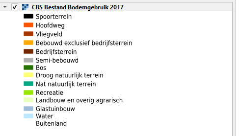
<Title>CBS Bestand Bodemgebruik 2017</Title> |
|
<Abstract>Het Bestand Bodemgebruik 2017 bevat digitale geometrie van het bodemgebruik in Nederland. Voorbeelden van het bodemgebruik zijn verkeersterreinen, bebouwing, recreatieterreinen en binnen- en buitenwater. De begrenzingen zijn voor een groot deel gebaseerd op de Top10NL (BRT). Bij het interpreteren zijn luchtfoto's leidend. De gegevens zijn ingewonnen in de zomer van 2017.</Abstract> |
|
<KeywordList> |
|
<Keyword>Landgebruik</Keyword> |
|
<Keyword>Nationaal</Keyword> |
|
<Keyword>CBS</Keyword> |
|
<Keyword>Bodemgebruik</Keyword> |
|
<Keyword>Land use</Keyword> |
|
<Keyword>Bodemfunctie</Keyword> |
|
<Keyword>BBG</Keyword> |
|
<Keyword>Bebouwing</Keyword> |
|
<Keyword>Wegen</Keyword> |
|
<Keyword>Spoor</Keyword> |
|
<Keyword>Natuur</Keyword> |
|
<Keyword>Vliegveld</Keyword> |
|
<Keyword>Bedrijfsterrein</Keyword> |
|
<Keyword>Bos</Keyword> |
|
<Keyword>Recreatie</Keyword> |
|
<Keyword>Landbouw</Keyword> |
|
<Keyword>Glastuinbouw</Keyword> |
|
</KeywordList> |
|
<CRS>EPSG:28992</CRS> |
|
<CRS>EPSG:25831</CRS> |
|
<CRS>EPSG:25832</CRS> |
|
<CRS>EPSG:3034</CRS> |
|
<CRS>EPSG:3035</CRS> |
|
<CRS>EPSG:3857</CRS> |
|
<CRS>EPSG:4258</CRS> |
|
<CRS>EPSG:4326</CRS> |
|
<CRS>CRS:84</CRS> |
|
<EX_GeographicBoundingBox> |
|
<westBoundLongitude>2.52713</westBoundLongitude> |
|
<eastBoundLongitude>7.37403</eastBoundLongitude> |
|
<southBoundLatitude>50.2129</southBoundLatitude> |
|
<northBoundLatitude>55.7212</northBoundLatitude> |
|
</EX_GeographicBoundingBox> |
|
<BoundingBox CRS="EPSG:28992" minx="-25000" miny="250000" maxx="280000" maxy="860000"/> |
|
<BoundingBox CRS="EPSG:25831" minx="-470271" miny="5.56231e+06" maxx="795163" maxy="6.18197e+06"/> |
|
<BoundingBox CRS="EPSG:25832" minx="62461.6" miny="5.56555e+06" maxx="397827" maxy="6.19042e+06"/> |
|
<BoundingBox CRS="EPSG:3034" minx="2.61336e+06" miny="3.509e+06" maxx="3.22007e+06" maxy="3.84003e+06"/> |
|
<BoundingBox CRS="EPSG:3035" minx="3.01676e+06" miny="3.81264e+06" maxx="3.64485e+06" maxy="4.15586e+06"/> |
|
<BoundingBox CRS="EPSG:3857" minx="281318" miny="6.48322e+06" maxx="820873" maxy="7.50311e+06"/> |
|
<BoundingBox CRS="EPSG:4258" minx="50.2129" miny="2.52713" maxx="55.7212" maxy="7.37403"/> |
|
<BoundingBox CRS="EPSG:4326" minx="50.2129" miny="2.52713" maxx="55.7212" maxy="7.37403"/> |
|
<BoundingBox CRS="CRS:84" minx="2.52713" miny="50.2129" maxx="7.37403" maxy="55.7212"/> |
|
<AuthorityURL name="cbs"> |
|
<OnlineResource xlink:href="https://www.cbs.nl/"/> |
|
</AuthorityURL> |
|
<Identifier authority="cbs">1339c2c0-ddc2-11de-2017-0800200c9a66</Identifier> |
|
<MetadataURL type="TC211"> |
|
<Format>text/plain</Format> |
|
<OnlineResource xmlns:xlink="http://www.w3.org/1999/xlink" xlink:type="simple" xlink:href="https://ngr.acceptatie.nationaalgeoregister.nl/geonetwork/srv/dut/xml.metadata.get?uuid=d9bf1ce1-5197-409e-b19e-340e50afafc4"/> |
|
</MetadataURL> |
|
<Style> |
|
<Name>bbg2017_hoofdgroep</Name> |
|
<Title>bbg2017_hoofdgroep</Title> |
|
<LegendURL width="78" height="20"> |
|
<Format>image/png</Format> |
|
<OnlineResource xmlns:xlink="http://www.w3.org/1999/xlink" xlink:type="simple" xlink:href="https://service.pdok.nl/cbs/bbg2017/wms/v1_0-preprod/legend/bbg2017/bbg2017_hoofdgroep.png"/> |
|
</LegendURL> |
|
</Style> |
|
<Style> |
|
<Name>bbg2017_omschrijving</Name> |
|
<Title>bbg2017_omschrijving</Title> |
|
<LegendURL width="78" height="20"> |
|
<Format>image/png</Format> |
|
<OnlineResource xmlns:xlink="http://www.w3.org/1999/xlink" xlink:type="simple" xlink:href="https://service.pdok.nl/cbs/bbg2017/wms/v1_0-preprod/legend/bbg2017/bbg2017_omschrijving.png"/> |
|
</LegendURL> |
|
</Style> |
|
<MinScaleDenominator>1</MinScaleDenominator> |
|
<MaxScaleDenominator>100000</MaxScaleDenominator> |
|
</Layer> |
|
</Layer> |
|
</Capability> |
|
</WMS_Capabilities> |