- Software and libraries
- Interferometric synthetic aperture radar (InSAR)
- Performing tropospheric noise corrections
- Multitemporal/time series InSAR analysis
- Simulator
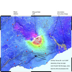
- Data


- site: https://www.researchgate.net/profile/Stefan_Auer/publications
- sources: https://github.com/StefanJAuer/RaySAR
The code in this folder is a synthetic aperture radar (SAR) simulator. It was written for my thesis called "SAR imaging with a hand-held UWB radar system" at Blekinge Institute of Technology in Karlskrona, Sweden, and served the purpose of simulating SAR images, as well as processing real radar images.
FFTW is a C subroutine library for computing the discrete Fourier transform (DFT) in one or more dimensions, of arbitrary input size, and of both real and complex data (as well as of even/odd data, i.e. the discrete cosine/sine transforms or DCT/DST).
- site: http://www.fftw.org
- sources: https://github.com/FFTW/fftw3
PyAPS is a python module that estimates differential phase delay maps due to the stratified atmosphere for correcting radar interferograms.
The Western North America InSAR (WInSAR) Consortium was established by a group of practicing scientists and engineers to facilitate collaboration in, and advancement of, Earth science research using radar remote sensing. Its members are universities, research laboratories, and public agencies. WInSAR oversees the acquisition and archiving of spaceborne SAR data over western North America for the benefit of the membership.